The land of the Mahafaly
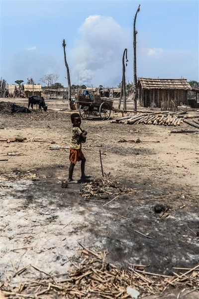
The country of Mahafaly, geographically defined by the Onilahy River in the north and the Menarandra River bounded to the south, actually begins at the level of RN 7. Most of the charcoal-burning and farming villages south of the mesa are inhabited by Tanalana migrants (population of the coastal plain of Mahafaly).
 From the eastern crystalline peninsula to the vast limestone plateau that slopes westward into the coastal plain, Mahafaly agricultural herders, constantly in search of new pastures, practice transhumance that strengthens their legendary cohesion.
Doesn't Mahafaly literally mean "you who make us happy"?
Until the end of the 19th century, the Mahafaly Kingdoms From their neighbors Antandroy, Antanosy (de Bezaha), Bara and Masikoro respected, and they did not spare the foreign traders, plundering the shipwrecks on their coasts and regularly raiding the trading posts.
If this region of the Great Subarid South remained mysterious and unexplored for a long time, today it is famous for the talent of its woodcarvers, the originality of its fauna and flora and its mineral wealth (fossils, gems and fine stones).
From ANDRANOVORY to BETIOKY
Andranovory (70 km from Toliara), this town marks the intersection of the RN 7 and RN 10 in its market. We sell roasted locusts per kilo when these insects kill the crops of the region.
The Tropic of Capricorn
The RN 10 crosses the Tropic of Capricorn about 45 km south of Andranovory. An opportunity to remember - not without nostalgic thoughts of one's geography textbooks - that this fictitious line, 23° from the equator, marks the southern limit of the transition from the sun to the zenith.
Bezaha
The ancient rice farmers of Taolañaro (Fort Dauphin), which this village, 59 km southeast of Andranovory above Inanavy and 22 km east of Tongobory, inhabit benefited from an ancient hydro-agrarian development.
Warm (55° C) and sulfurous water, evidence of active volcanism, deafening here and there. The thermal complex built by the South Africans in the 1960s on construction sites, unfortunately, is completely dilapidated.
Bezaha-Mahafaly reserve
These 600 hectares of thorny forest on the left bank of the River Onilahy host specimens of most plant and animal species of Madagascar's south (lemurs, rayed tortoises and Malagasy hedgehogs, or tenrecs...).
A permit from the National Association for the Management of Protected Areas (ANGAP) is required to visit, and it is recommended that you take a guide with you as it is complicated to get there.
FROM BETIOKY TO THE MOZAMBIQUE CHANNEL
Passing the commercial city Tongobory RN 10 is lined with imposing tombs, which are important for the culture  Mahafalys are characteristic. It crosses the dry forest at the foot of small hills to reach Betioky (23 km south). This small town with its streets lined with ornamental baobabs is very lively on market days.
Under the arcades of the city center, seamstresses work to order on antique Chinese copies of Singer sewing machines, while rubies and amethysts are traded at the stalls next to the bush cab station.
Not far from the beautiful tombs, at the entrance of the city, an art workshop offers bed wood, chests, honey boxes and copies of antique aloalo (carved and painted burial sticks).
The coastal plain Tanalana
Leaving RN 10 24 km south of Betioky to take the Itambono corridor, it is possible to make an unforgettable trek in the deep south, provided you have a 4×4, camping gear and fuel reserves.
 From Vezo Village Beheloka at the end of the path you can follow the coastline to Soalara and Anakao Follow 62 km north or venture the great adventure to Androka in the south.
The track is difficult and unrolls its sandy ribbon between an emerald green sea fringed by lagoons and the fantastic scrub vegetation: Fantsiholitra, huge thorn trees of unreal green whose trunks resemble monkey arms, rondroho or sausage trees, tamarind and prickly pear trees or riketa.
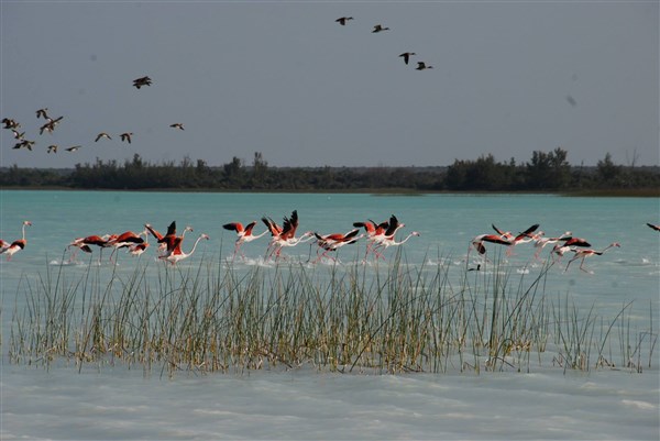
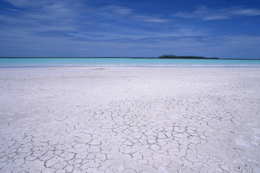
Integral nature reserve of Tsimanampetsotsa (30 km southeast of Beheloka).
It is organized around the salt lake of Tsimanampetsotsa, a huge milky-white water table lined with petrified trees where hundreds of flamingos, plovers and other wading birds roam.
The lake is also home to the famous Typhleotris, an extremely rare blind fish. This reserve of 43 000 ha is not always accessible, it is better to check with ANGAP.
Sakoa coal
From Ambatry (16 km south of Betioky), a road leads 62 km east to the former mining center of Ankinany. In the 1940s, there were plans to cover the entire South with Sakoa coal to industrialize.
There was even a railroad in the Itambono Corridor installed to transport the ore to the port of Soalara in Anantsoño Bay, as evidenced by the rails and wagons abandoned in the bush.
 This low-grade, sulfurous ore was occasionally used to feed the slaughterhouses of La Rochefortaise in Toliara until the 1970s.
Androka (81 km west of Ampanihy), if you camp near this Vezo village at the mouth of the Linta River, you can enjoy the beautiful beaches at Ampalaza Bay, explore the coral reefs and embark with the fishermen to Nosy Manitse.
From Androka from a fork in the road leads to the RN 10 at Ampanihy and at the bend in the river the Linta you can discover the royal tombs built on the river bank (Betioky - Ampanihy: about 280 km).
Beahitse (52 km from Betioky on RN10), South of Betioky, impressive tombs decorated with aloalos stand on the side of the main road. Passing Beahitse, the only large village between Betioky and Ejeda, cacti and baobabs give way to sisal fields and prickly pear hedges.
Ejeda
At the entrance to this large shopping town, 84 km south of Betioky, a stone bridge spans the Linta, a river that in winter turns from a thin trickle into a raging torrent in the rainy season.
Herds of zebus come here to drink, while washerwomen spread colorful lambahoany in the sun. According to some people, Ejeda owes its name to a formidable colonial-era adjutant or French ejeda.
Gold mine
The trail that opens on the right side of RN 10, 5 km south of Ejeda, before Beholiva, leads to placers (ponds lined with earthen dams, ditches and thatched huts) where gold miners are active.
Ruby Mines
To visit the ruby mines, it is advisable to contact the Fokontany (Municipality) and the hoteliers of Ejeda and to take a good guide, since the route is quite complicated: follow the path that passes through Gogogogo northeast of Ejeda to Bekily and then branch off to Vohitany, the regional correctional center.
Mountains of sand and gray stones mark the massive excavation, from which muffled blows of crowbars and chisels rise from far and wide.
In the valleys that Ejeda separate from Ampanihy (50 km), the landscape gradually becomes more humane: pastures are joined by valleys (fenced fields) with thorn trees, some rice fields and magnificent mango trees.
Ampanihy
With its administrations, its numerous stores, its hospital and its high school, this city is indeed the capital of Mahafaly country, but it is particularly proud of its amazing Saturday morning market.
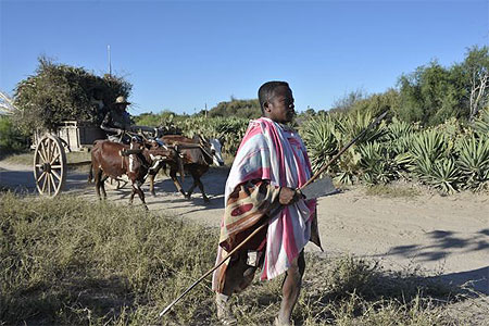
Agropastoralists flock about a hundred kilometers in their oxcarts to the main square to  crushed rice, cassava, corn, sugar cane, poultry, vegetables and vegetable plants, fish, shells, knives, reeds for weaving, sorrel (lichen from which a dye is obtained), carved objects made of wood or plastic, clothes, hats ... for sale.
Besides the exoticism of the products, it is necessary to insist, together with François Sabelli (Les Marchés ruraux d'Afrique noire, Universalia 1985), on this vocation of a "peripheral market in which economic negotiations are only the apparent aspect of a political relationship in which the prestige of one is opposed to the calculation of the other".
Ampanihy is also a mining center. Prospectors come to offer tourmalines and garnets to travelers, while the Delorme company, located on the outskirts of the city, sends fine stones to the capital which, once cut, become solitaire pieces and ornamental spheres.
After Ampanihy the relief becomes more hilly and the route more difficult.
In the bush that stretches as far as the eye can see, the distances seem to grow ever greater.
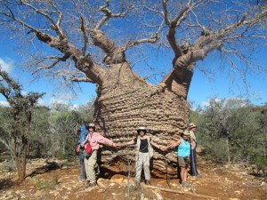
Only the graves rising on either side of the path and, in the distance, a baobab tree with a large trunk break the unity of the landscape.
Mohair carpets
Due to the increasing shortage of Angora goats and, above all, serious management errors, the company, founded in the late 1940s, closed down Mohair House of Ampanihy, which quickly became a cooperative, opened its doors in the early 1980s.
 However, the weavers, who are either self-employed or work for a commercial network, still produce magnificent mohair rugs with 20,000 stitches, brown and/or white, with aloalo, mahafaly or antandroy cross patterns.
The carpets, more than 20 square meters, are called buses in memory of one of the first large buses that served Ampanihy.
Passage of the river Menarandra
41 km south of Ampanihy the line crosses the Menarandra, a river whose wide bed separates the land of Mahafaly from the Androy. Cattle herders lead there to bathe their zebus, under the guard of the two monumental tombs decorated with frescoes, wooden surfaces and bucranes, facing each other on the hill above the left bank.
 Tranoroa (41 km east of Ampanihy), this large village lost in the bush with a grocery store as its only business is the center of graphite mining operated by South African companies.
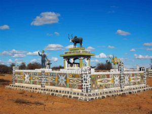
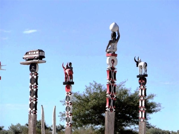
Mahafaly Tombs
Like the Antandroids, the Mahafaly built huge individual tombs, often more than 200 m² in size, modeled on the royal tombs.
Bucranes and Aloalo (carved and painted wooden posts) adorn their tops, and naively painted geometric motifs or scenes from the daily life of the deceased sometimes run along the masonry walls.
The construction of these memorial graves and the ceremonies that precede the burial can take several months and involve very costly zebu hecatomizations. The Mahafaly are quite tolerant of the presence of strangers at these ceremonies.